Instead of running the Mount Summit Challenge on April 26, 2020, canceled because of the coronavirus, I wanted to replicate the elevation gain in some way, but off the beaten path. The Mount Summit Challenge climbs 3.5 miles with 1,200 feet of elevation gain, an arduous uphill road race that I so love.
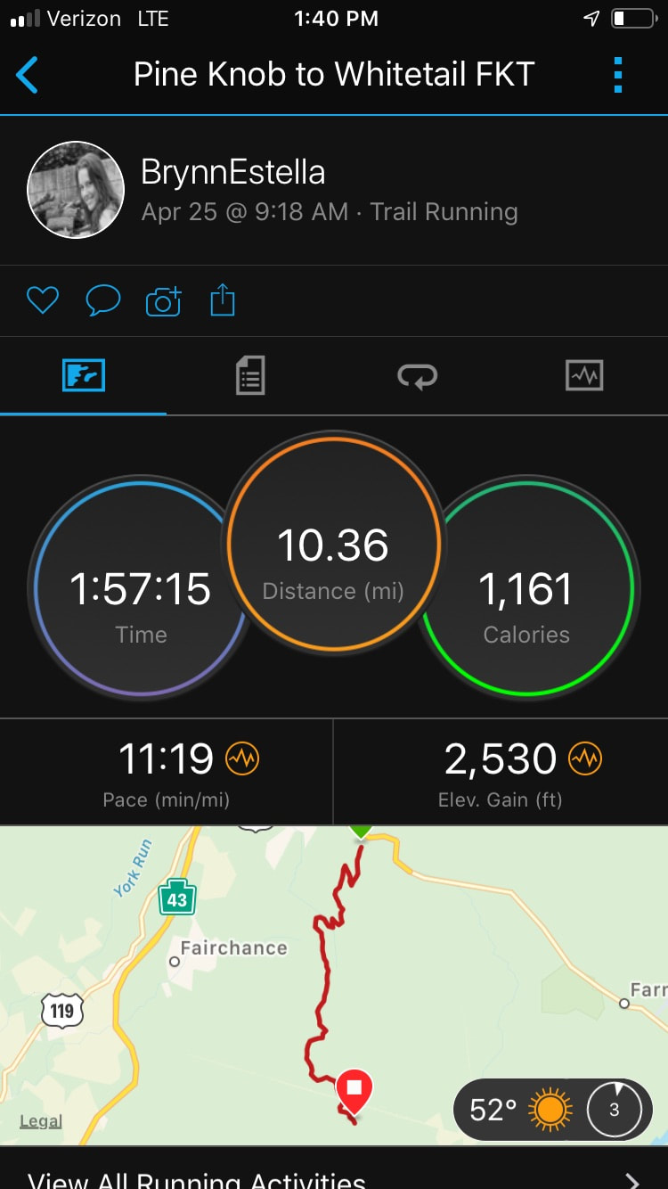
For my trail challenge, and keeping with the spirit of the Summit's steepness, I chose the 10.36-mile (according to my Garmin fenix5s) point-to-point Pine Knob to Whitetail Trail, because the starting location is at Lick Hollow, about the two-mile point of the Mount Summit Challenge. Instead of climbing up the two-lane pavement of Route 40, I would be climbing through the woods.
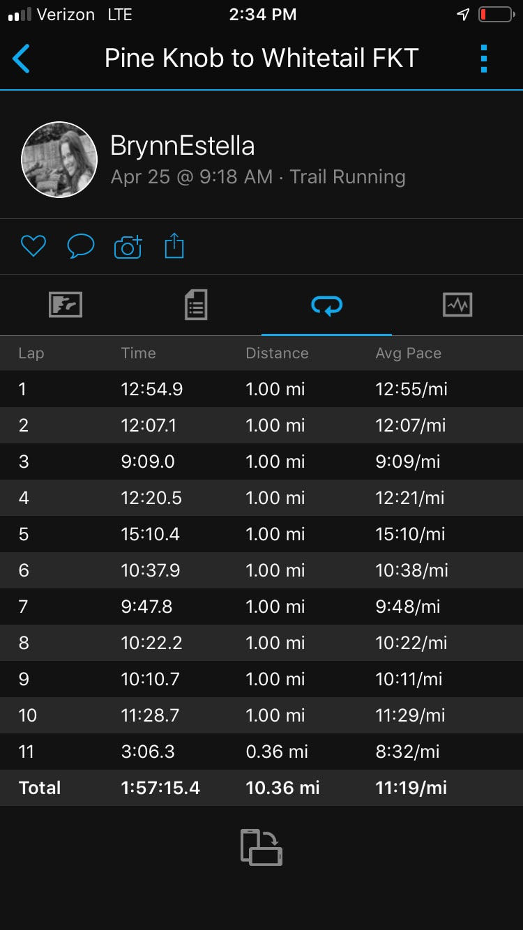
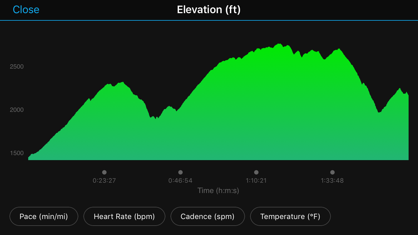
The first four miles of Pine Knob to Whitetail gains 1,125 feet in elevation, followed by the route's steepest climb (from mile four to five), which gains 519 feet in that single mile. In other words, 1,634 feet of gain within five miles, on tricky terrain - close enough for me to the Summit's profile!
To top off the challenge, I ran it to establish the first official female unsupported Fastest Known Time (FKT, a trail running speed record), my third one of the year. On March 1, I established the Big Savage Mountain Trail FKT and on April 22, the Bear Run Nature Reserve Black Loop FKT. Not sure what an FKT is? Click here to find out.
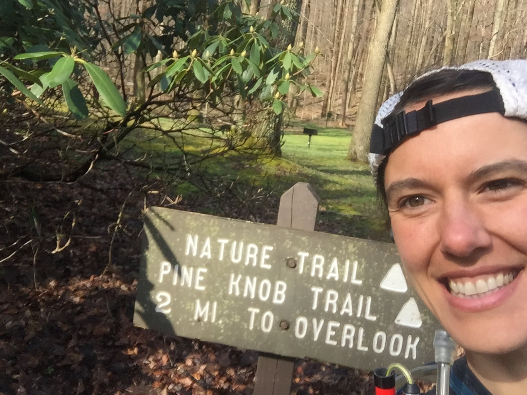
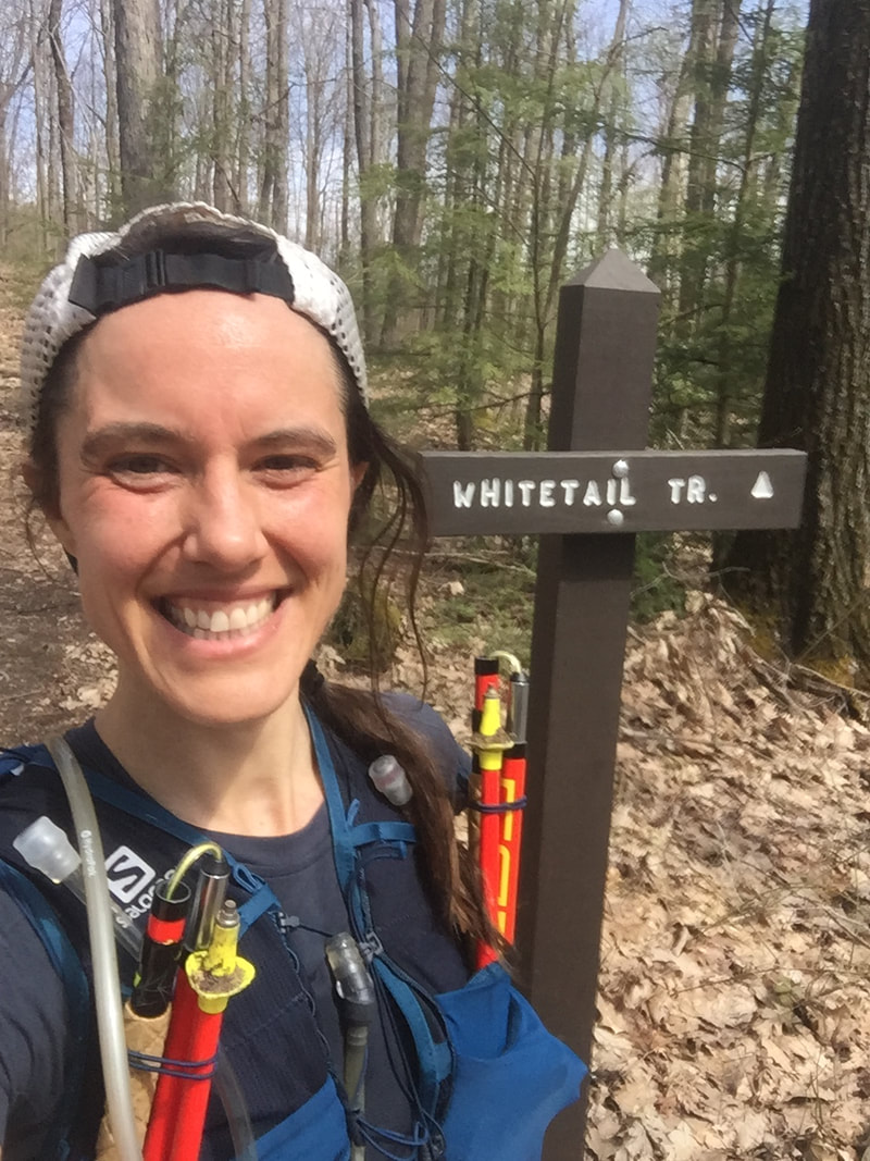
I started at the sign at Lick Hollow Picnic Area that says "Nature Trail/ Pine Knob Trail/ 2 Mi. to Overlook," making it the now official FKT start line (see pictures below).
The route consists of a variety of softball-sized loose rocks, technical, rocky terrain, wide, leafy ditches, narrow, sloping switchbacks, one mile of slick-mud forest service road, fun single track, clear-cut crossings and connections, steep pitches, creek crossings, moss-covered ground, wide grassy and gravel roughness, and is often wet, or at least damp, and muddy.
I crossed the invisible finish line, stopping my watch, after the climb out of the creek in Quebec Run Wild Area, after crossing the dirt Quebec Road, when both feet hit the North Gate parking lot, signifying the now official finish.
For my trail challenge, and keeping with the spirit of the Summit's steepness, I chose the 10.36-mile (according to my Garmin fenix5s) point-to-point Pine Knob to Whitetail Trail, because the starting location is at Lick Hollow, about the two-mile point of the Mount Summit Challenge. Instead of climbing up the two-lane pavement of Route 40, I would be climbing through the woods.
The first four miles of Pine Knob to Whitetail gains 1,125 feet in elevation, followed by the route's steepest climb (from mile four to five), which gains 519 feet in that single mile. In other words, 1,634 feet of gain within five miles, on tricky terrain - close enough for me to the Summit's profile!
To top off the challenge, I ran it to establish the first official female unsupported Fastest Known Time (FKT, a trail running speed record), my third one of the year. On March 1, I established the Big Savage Mountain Trail FKT and on April 22, the Bear Run Nature Reserve Black Loop FKT. Not sure what an FKT is? Click here to find out.
I started at the sign at Lick Hollow Picnic Area that says "Nature Trail/ Pine Knob Trail/ 2 Mi. to Overlook," making it the now official FKT start line (see pictures below).
The route consists of a variety of softball-sized loose rocks, technical, rocky terrain, wide, leafy ditches, narrow, sloping switchbacks, one mile of slick-mud forest service road, fun single track, clear-cut crossings and connections, steep pitches, creek crossings, moss-covered ground, wide grassy and gravel roughness, and is often wet, or at least damp, and muddy.
I crossed the invisible finish line, stopping my watch, after the climb out of the creek in Quebec Run Wild Area, after crossing the dirt Quebec Road, when both feet hit the North Gate parking lot, signifying the now official finish.
The Trip Report:
Pine Knob to Whitetail Trail
Saturday, April 25, 2020
10.36-mile point-to-point
Elevation gain: 2,530 feet
Elevation loss: 1,801 feet
Weather: 52 degrees, balmy, sunny
Unsupported/Female
Trail conditions: Dry except in the spots that are always wet ;)
Pine Knob to Whitetail Trail
Saturday, April 25, 2020
10.36-mile point-to-point
Elevation gain: 2,530 feet
Elevation loss: 1,801 feet
Weather: 52 degrees, balmy, sunny
Unsupported/Female
Trail conditions: Dry except in the spots that are always wet ;)
Mile zero to one to two: I started at the sign pictured above, which sits in the grass near the road/first bridge you cross when entering Lick Hollow Picnic Area; Run through the swampy grass to the loose, wet, muddy rocks to start, then turn right at the Pine Knob sign, where the narrow, sloping trail begins it's ascent. The switchback made it's hard right-hand turn when my watch was at approximately one mile.
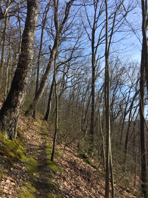
Mile one to two: Narrow, pretty, trail (pictured below). Turn left at the Whitetail sign at about 1.5 miles, then quickly turn left onto the slick-mud forest service road (Pine Knob Road). For the FKT route, skip the Pine Knob Overlook by making these two left-hand turns, which keep you heading directly on the Pine Knob to Whitetail traverse. The overlook veers away from the main trail and sits off to the right.
Mile one to two: Narrow, pretty, trail (pictured below). Turn left at the Whitetail sign at about 1.5 miles, then quickly turn left onto the slick-mud forest service road (Pine Knob Road). For the FKT route, skip the Pine Knob Overlook by making these two left-hand turns, which keep you heading directly on the Pine Knob to Whitetail traverse. The overlook veers away from the main trail and sits off to the right.
Mile two to three: Run along the wide road for one mile then turn right, back onto the wooded, moss-covered path. Wide downhill leading to the Redstone Creek crossing. Follow the red blazes!
Mile three to four: Crossing and then climbing out of Redstone Creek - keep your eyes on the red blazes.
Mile four to five: With 1,125 feet of elevation covered, this is the biggest climb, at 519 feet in one mile. I whipped out my Leki Micro Trail Race Pro poles and used them for half a mile, still coming to a walk, resulting in the slowest lap of the run. This was the only part where I used the poles - they took away some of the burning in the legs!
Mile five to six: Fun, narrow path begins again, gradual climbing, crossing a clear cut with two helpful Whitetail Trail signs to guide the way.
Mile six to seven: At 10K, pass the Skyline Drive parking lot, then at about 6.5 miles, cross the double-lane Skyline Drive.
Miles seven to eight: Playful single-track
Mile eight to nine: The mileage here is approximate - the trail comes out to a wide gravel road, requiring a left-hand turn. It is framed by many trees with blue markings, sometimes with other colored markings, with some indication of logging. Keep watching the red blazes, follow the gravel which turns into dirt which turns into grass, eventually bearing left and then right to run downhill to enter Quebec Run Wild Area. This is the steepest downhill of the route at 377 feet of loss.
Mile nine to finish (10.36 miles): Cross a clear cut with briers, run through the refreshing, frigid creek (feet will get wet), bear right to climb to the finish. I ran across the dirt road, Quebec Road, and stopped my watch when both feet hit the parking area, signifying the end of the route, the finish line.
Please note that I have come to know this route very well over time, like the back of my hand, I have become acquainted with every turn and nuance, providing for zero time wasted on navigating or trying to locate blazes.
Mount Summit Challenge, I dedicate this run to you and all the friends and family I missed seeing there this year. I hope to see you next year.
xo,
Brynn
"Shanti Raksha"
xo,
Brynn
"Shanti Raksha"


 RSS Feed